Having a prominent location near Taxila, Rawalpindi and Islamabad, Faisal Hills is an extraordinary housing society. The ongoing project is located along the Main GT (Grand Trunk) Road and is easily accessible from Rawalpindi and Islamabad. Another major factor that play’s in Faisal Hills (Housing Scheme)is its strategic location and allied infrastructure, attracting investors and homebuyers who are looking for a modern community that is well-connected and secure.
Prime Location with Excellent Connectivity
Faisal Hills is situated close to the historically and archaeologically important Taxila region, which is also developing as an urban center. The society is just a short drive away from highways and major roads, ensuring seamless everyday travel. Faisal Hills is accessible through its main access point GT Road, which assures seamless connectivity with key areas of Rawalpindi, Islamabad and others.
According to the Faisal Hills location map, the project is near the M-1 and M-2 motorways. This allows access to major cities such as Peshawar, Lahore, and more.
Faisal Hills offers convenience and accessibility. Residents and investors benefit from nearby workplaces, schools, shopping centers, and recreational outlets.
A major advantage of Faisal Hills’ location is its proximity to the New Islamabad International Airport. The airport is only a short and smooth ride away.
This makes Faisal Hills a popular choice for frequent travelers, business people, and expatriates. Many expatriates prefer it when they visit Pakistan often.
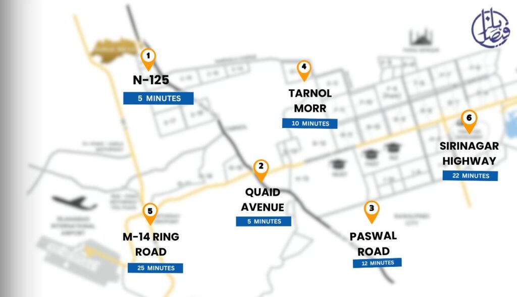
N-125 – 5 minutes
Quaid Avenue – 5 minutes
Kalabagh-Nathia Gali Road – 6 minutes
Tarnol Morr – 10 minutes
Paswal Road – 12 minutes
Kohat-Rawalpindi Road – 21 minutes
M-1 Peshawar-Islamabad Motorway – 22 minutes
Srinagar Highway – 22 minutes
M-14 Ring Road – 25 minutes
M-2 Islamabad-Lahore Motorway – 28 minutes
Taxila City – 7 minutes
Wah Cantt – 10 minutes
Sector B-17 Islamabad – 12 minutes
Rawalpindi – 25 minutes
Islamabad – 30 minutes
Taxila Museum – 8 minutes
Heavy Mechanical Complex (HMC) – 9 minutes
Pakistan Ordnance Factories (POF) – 11 minutes
New Islamabad International Airport – 35 minutes
Golra Sharif Railway Station – 20 minutes
Margalla Hills National Park – 30 minutes
Wah Gardens – 12 minutes
Faisal Hills Location Map
The Faisal Hills location map must clearly show how well-connected the society is. It should also highlight its exact location as a fresh and prime residential community under development.
This is a well-planned residential housing project. It is situated on the Main GT Road near Taxila. The location provides easy access from both Rawalpindi and Islamabad.
Why the Location Map Matters?
Investors and homebuyers need location maps to understand where a housing society is situated. These maps show its position within the larger settlement and highlight the areas it connects to.
Faisal Hills offers a promising investment opportunity due to its industrial, commercial, and residential development. It is located in the scenic region of Ghaziabad Moharram Hill.
A detailed location map attracts potential buyers by providing a clear visual representation of the society. It helps them identify entry points, nearby facilities, and potential future expansion areas.
Faisal Hills Location not only increases its real estate value but also provides its residents with a modern-day well-organized lifestyle.